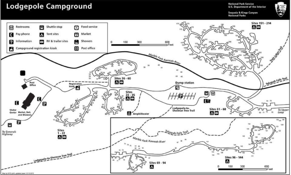
Lodgepole Campground
Overview
Lodgepole Campground is located in the breathtaking Sequoia and Kings Canyon National Parks in central California’s rugged Sierra Nevada range. Lodgepole is perched on the banks of the scenic and lengthy Marble Fork of the Kaweah River, at an elevation of 6,700 ft. The inspiring Giant Forest Grove and the mighty General Sherman Tree – the world’s largest tree in volume – are just two miles from the campground.
Facilities
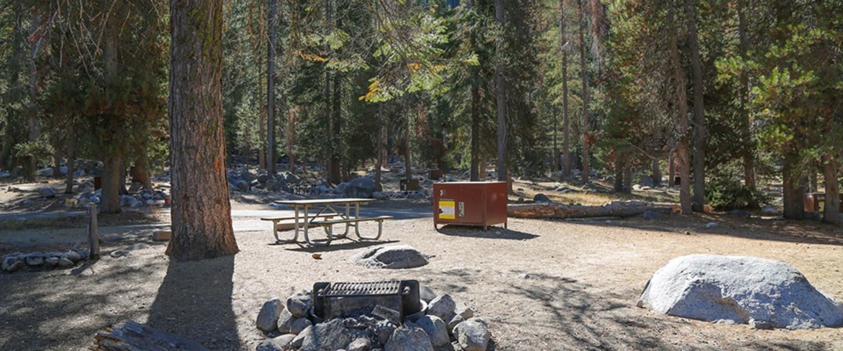
Lodgepole Campground is very popular with tent and RV campers alike. It has paved roads, flush toilets, and drinking water. Picnic tables, fire rings, and bear food storage boxes are provided at each site. Lodgepole Village is a quick, 1/4-mile away, offering a visitor center, nightly Interpretive Ranger programs, a market, deli, snack bar, gift shop, post office, coin-operated showers, and laundry facilities.
Natural Features
Lodgepole pine, Red fir, and shrubs forest the campground while towering groves of giant sequoias and craggy granite peaks dot the landscape. The Marble Fork of the Kaweah River is fed by snowmelt and flows seasonally through the site. This region is characterized by warm days and cool nights in the summer and deep snow and cold days in the winter.
Nearby Attractions
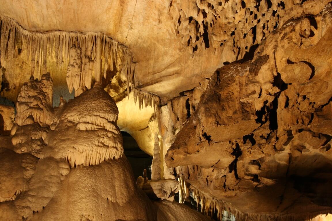
The General Sherman Tree, General Grant Tree, Moro Rock, and Tunnel Log are nearby, as is the informative Giant Forest Museum. Colorful Crescent Meadow offers views of vivid summer wildflowers and access to Tharp’s Log, a cabin in a fallen sequoia. Tours into Crystal Cave, one of hundreds of marble caves in the park, give visitors an interesting view of rock formations, fossils, rare minerals, and unique wildlife. Tickets are required but are not sold at the cave entrance. Reserve in advance on www.recreation.gov. Tickets may also be purchased same day, if available, at the Lodgepole Visitor Center. Crystal Cave is about a 45-minute drive (13 miles/21 km) from the campground. Vehicles longer than 22 feet long are prohibited on Crystal Cave Road.
Recreation
Forty miles of trails, including the paved Big Trees Trail, invite visitors to immerse themselves in the majesty of the ancient grove. Several additional popular hiking and wilderness trailheads are close by, including the trail to Moro Rock, a granite dome with spectacular views of the Great Western Divide and western half of the park. Tokopah Falls Trail is an easy walk along the Marble Fork of the Kaweah River, leading to an impressive 1200 ft. waterfall. Fly-fishing is also a popular activity on the Marble Fork.
Driving Directions:
Both roads leading to Sequoia and Kings Canyon National Parks approach from the west. These roads are open all day, every day, depending on weather and construction activities. From the east, no roads reach the park boundary. The Main park road, The Generals Highway, connects the north and south entrances. Winter storms may cause temporary closures from Grant Grove to Lodgepole. From Highways 65 or 99: Go east on Hwy 198 E and follow signs for Sequoia National Park to the park entrance (about 1 hour to Lodgepole). Highway 180 E may be reached from Highway 198 E using Hwy 63 N from Visalia. Notice: Vehicles longer than 22 feet must enter the parks from the Kings Canyon National Park (Hwy 180 E) entrance. From Fresno: take Highway 180E, following signs for Kings Canyon National Park to the park entrance (about 1 hour to Lodgepole). Once in the park, follow signs to Sequoia National Park and Lodgepole.
Recreation Sites
Standard Nonelectric
Tent Only Nonelectric
Walk To
Rv Nonelectric
Overnight
Important Dates
November 28th 2018 – April 17th 2019 Campground Closed for Winter
April 17th 2019 – May 21st 2019 Campground Partially Open: Self-registration
May 22nd 2019 – September 24th 2019 Campground 100% Open: Reservations Only
September 25th 2019 – December 3rd 2019 Campground Partially Open: Self-registration
December 4th 2019 – April 16th 2020 Campground Closed for winter
Activities
Other Recreation Concession Site
Day Use Area
Visitor Center
Hiking
Interpretive Programs
Camping
Amenities
Accessible Campsites
Amphitheater
Dump Station
Grocery Store
Post Office
Ranger Station
Shuttle Bus Service
Grills/Fire Ring
Picnic Table
Tent Pad
Food Locker
Grills
Campfire Rings
Food Storage Locker
Picnic Tables
Fire Pit
BBQ
Need to Know
Federal Highways Construction Advisory: Vehicles longer than 22 feet will be prohibited on the Generals Highway between Hospital Rock and the Giant Forest Museum, starting March 19, 2018. This closure will remain in effect until construction has been completed. During construction, the FHWA will close one lane of the highway by blocking it with K-rail. This will narrow the highway, making it unable to safely accommodate vehicles over 22 feet. The highway closure is being extended to the nearest turn around locations for vehicles of that size to the south at Hospital Rock and north at Giant Forest Museum. Visitors with vehicles over 22 feet hoping to visit the Giant Forest or camp at Lodgepole and Dorst Creek Campgrounds are advised to enter via the Hwy 180 (northern) entrance to these parks.
This is an American Black Bear habitat: all food, scented items, coolers and garbage must be properly stored in provided bear-resistant food storage boxes, not in your vehicle, 24 hours/day. Food-storage box dimensions are 28′ high x 33′ deep x 47′ wide.
There are no electric, water or sewer hookups; a free dump station is nearby with drinking water.
No generators are allowed in sites #36-60 and 69-144. Generator Hours are 8:00-11:00 am and 5:00-8:00 pm.
Please don’t travel with firewood; get it at or near your camping destination. Help protect these parks from invasive species, such as insects, fungi and other pests living in firewood that can spread beyond campgrounds threatening the health of the forest. Local markets sell firewood and gathering dead and down wood is allowed.
Note: Skateboards and Scooters are not allowed to be used on park roadways, including in the campgrounds.
Bicycle use is not allowed on any park trails.
Vehicles must be parked with all wheels on asphalt pavement. Extra vehicles can be parked in overflow parking areas. Do not park on vegetation
Pets must be on a 6 foot or shorter leash at all times, and may not be left unattended and tied to an object. Pets are not permitted in the backcountry, on any park trails, or in any buildings.
Shuttle service runs from Visalia to the Giant Forest within Sequoia National Park from Memorial Day Weekend through Labor Day Weekend; shuttle reservations are required for getting to the park and can be obtained by calling 1-877-BUS-HIKE
A separate free shuttle service runs within the Giant Forest / Lodgepole area of Sequoia National Park with stops at the Wuksachi Lodge, Lodgepole Visitor Center and Market, Lodgepole Campground, Upper and Lower General Sherman Tree parking, Giant Forest Museum, Moro Rock and Crescent Meadow, and Dorst Creek Campground.
A California state fishing license is required to fish in Sequoia and Kings Canyon National Parks, and Sequoia National Forest lakes and streams. Fishing licenses available at National Park and National Forest markets.
Cell service is unreliable and limited in the parks.
GPS Coordinates:
Latitude:
36.6067111
36° 36′ 24.1600″ N
Longitude:
-118.7258
118° 43′ 32.8800″ W
Contact Information
Lodgepole Campground-Sequoia and Kings Canyon National Park
SEQUOIA AND KINGS CANYON NATIONAL PARKS
47050 GENERALS HIGHWAY
Three Rivers, CA 93271
Phone Number:
For campground inquiries, please call: 559-565-3341
Credit
https://www.recreation.gov/camping/campgrounds/232461
Photo and map credit from NPS https://www.nps.gov/seki/planyourvisit/lodgepole.htm
