
Sequoia Complex (#sqfcomplex) – September 12, 2020.
***Please note – the maps are dated 9/11/20, an infrared flight was not flown last night and we do not have maps for 9/12/20.***
A Haines Index of 6 is predicted for today. This means that there is instability in the atmosphere and a high potential for the fire to exhibit erratic fire behavior. Active fire behavior is expected today.
Information provided from a press release from the Sequoia National Forest
Sequoia (#SQF) Complex: Because an infrared flight was not flown last night due to mechanical issues, updated acreages are not available. Acreages remain 67,516 acres for the Castle Fire and 577 acres for Shotgun fire, with 68,093 total acres.
Castle Fire: On Friday, the western flank of the fire was presented with challenging weather conditions, with ridge level winds coming in from the east, pushing the fire west. At approximately a mile and a half north of White Meadow, the fire became active and spotted over the containment line. A smoke column was visible in this area. Hotshot crews, structural firefighting engines, and heavy helicopters worked aggressively to catch spot fires and secure the line. By the evening, winds shifted back in firefighter’s favor. This western edge continues to be a challenging piece for fire crews. Due to its complexity, terrain, values at risk, and safety of firefighters and the public, fire managers are slowly implementing strategies that have a high probability of success. Incident Commander Mike Goicoechea, encouraged firefighters by reminding us all that, “this is a marathon, not a sprint.”
On the eastern side of the fire that pushes out towards Beach Meadows, hand crews and dozers continue to construct line on the south side of the fire finger. Crews are going direct and will eventually bring their work around the tip. Further east, crews continue to assess structures within Long Canyon and Monache Meadows. A firefighter module of ten people was inserted on the northern point of the fire in Sequoia National Park. These firefighters will work to provide structure protection around Kern Canyon.
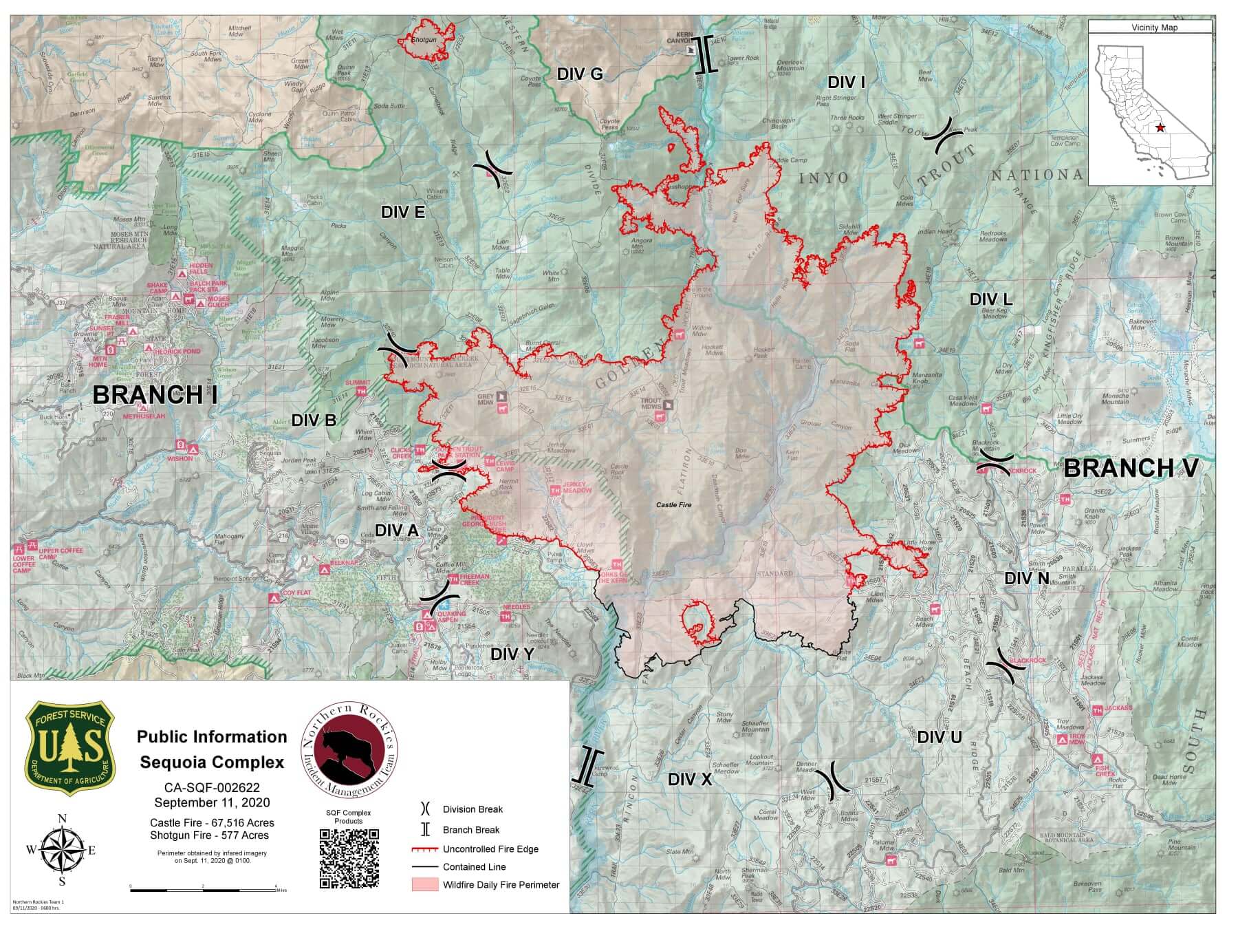
Today, crews will continue work with the prioritization of their efforts being on the critical western edge. If feasible, crews may use firing operations to strengthen existing containment lines, however any burning will have to be carefully planned given the potential for erratic and shifting winds. Later this afternoon, upslope winds will develop and there will be an opportunity to be able to complete containment line at a higher pace on the western edge. The structural group remains an integral part of this entire operation and has been busy preparing roads, transporting firefighters and water, as well as becoming familiar with all area communities at risk.
Shotgun Fire: The fire remains at 577 acres and continues to exhibit low intensity surface fire in sparse fuel.
Weather: Today’s weather will be several degrees warmer (84 to 90 degrees) and relative humidity percentage levels (8 to 13%) will be lower, bringing increased instability to the fire area. East to southeast winds will remain aloft on the ridges today, with upslope winds developing in the late afternoon.
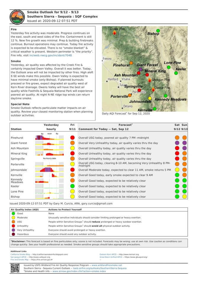
Smoke: Current weather conditions are anticipated to push smoke to the west of the fire area for the next couple days. For current air quality, visit: https://fire.airnow.gov/.
Evacuations and Closures:
• Evacuation Orders from the Tulare County Sheriff are in effect for the following communities: Camp Nelson, Coy Flat, Mountain Aire, Pierpoint, and points between (issued 9/6/20), Alpine Village, Sequoia Crest and Redwood Drive (issued 9/4/20), Ponderosa, Cedar Slope, Pyles Camp, and points between (8/28/20). An Evacuation Warning is in place for Doyle Springs.
• For assistance with evacuation, contact the Red-Cross at 1-800-RED-CROSS or https://tinyurl.com/yafetgkj
• Tulare County residents are encouraged to sign up for emergency notifications at alerttc.com
• Park and Campgrounds closures: Mountain Home Demonstration State Forest; Tulare County’s Balch Park Campground; and all the campgrounds within the Sequoia and Inyo National Forests.
• All National Forests in California are currently closed as of September 9, 2020.
• Current conditions in Sequoia and Kings Canyon National Parks may be found at: https://tinyurl.com/y3q9x5l8.
• For current information on California Highways, visit https://dot.ca.gov/ .
• The current Temporary Flight Restriction for the Sequoia Complex may be found by clicking here. The use of drones over the fire is also prohibited.
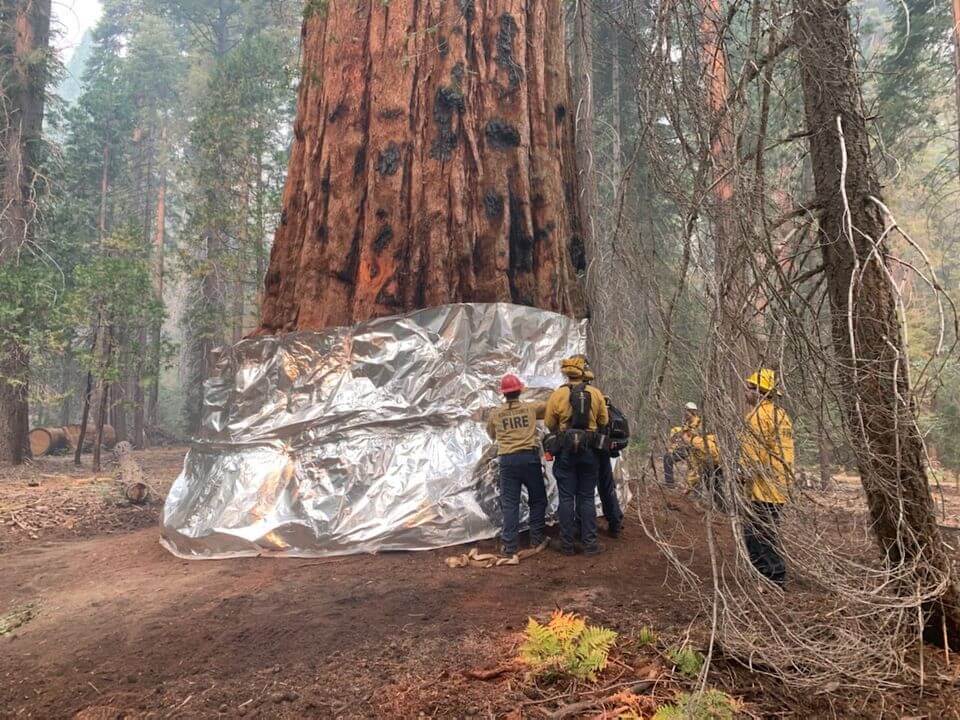
Priorities include: Communities listed in the above evacuation orders, Casa Vieja, Blackrock Ranger Station, Rogers Camp, Beach Meadows, Monache Meadows, structures along the Lloyd Meadows Road, Freeman Grove, the President George H.W. Bush Tree, Camp Whitsett, archeological values, Mountain Yellow-Legged Frog and Little Kern Golden Trout Critical Habitats, Pacific Fisher habitats, OSA, Beach, and Beck Meadows, trailheads and facilities.

