The Secret of the Big Trees

In the days of the Prophet Elijah sore famine afflicted the land of Palestine. No rain fell, the brooks ran dry, and dire distress prevailed. “Go through the land,” said King Ahab to the Prophet Obadiah, “unto all the fountains of water and unto all the brooks; peradventure we may find grass and save the horses and mules alive, that we lose not all the beasts.” When Obadiah went forth in search of forage he fell in with his chief, Elijah, and brought him to Ahab, who greeted him as the troubler of Israel. Then Elijah prayed for rain, according to the Bible story, and the famine was stayed.
This article written by Dr. Ellsworth Huntington (1876 – 1947) of Yale University, New Haven, Conn appeared in the July 1912 issue of Harper’s Magazine, and is copied here in a revised form with the addition of photographs of some of the big trees in the national parks. The contents also appeared in a book published by the Department of Interior in 1913. The content on this page was copied from a 2007 version from the NPS site, with modern edits noted). Copies of the tree ring measurements exist on oversized charts in the Yale University Library, Room 147, MS1, folders 175-176 in folios 13-14. Ellsworth was a pioneer in the measurement of tree-rings as climatic indicators.
From this famine in Palestine, some 870 years before Christ, to the forests of the Sierra Nevadas, in the year of grace 1911, is a far cry. The idea of investigating an episode of ancient Asiatic history in the mountains of California seems at first sight quixotic. Yet for the purpose of facilitating such an investigation the Carnegie Institution of Washington furnished funds, and Yale University gave the author leave of absence from college duties. The men in charge of both institutions realize that the possibilities of any line of research bear no relation whatever to its immediate practical results, or even to its apparent reasonableness in the minds of the unthinking. The final outcome of any piece of scientific work may not be apparent for generations, but that does not make the first steps less important. Already, however, our results possess a positive value. They demonstrate anew that this world of ours, with all its manifold activities, is so small, and so bound part to part, that nearly 3,000 years of time and thrice 3,000 miles of space can not conceal its unity.
The connecting link between the past and the present, between the ancient East and the modern West, is found in the big trees of California, the huge species known as Sequoia washingtoniana. Everyone has heard of this tree’s vast size and great age. The trunk of a well-grown specimen has a diameter of 20 or 30 feet, which is equal to the width of an ordinary house. Such a tree often towers 250 or 300 feet, or six times as high as a large elm, and within 50 feet of the top the trunk is still 10 or 12 feet in thickness. Three thousand fence posts, sufficient to support a wire fence around 8,000 or 9,000 acres, have been made from one of these giants, and that was only the first step toward using its huge carcass. Six hundred and fifty thousand shingles, enough to cover the roofs of 70 or 80 houses, formed the second item of its product. Finally there still remained hundreds of cords of firewood which no one could use because of the prohibitive expense of hauling the wood out of the mountains. The upper third of the trunk and all the branches lie on the ground where they fell, not visibly rotting, for the wood is wonderfully enduring, but simply waiting till some foolish camper shall light a devastating fire.
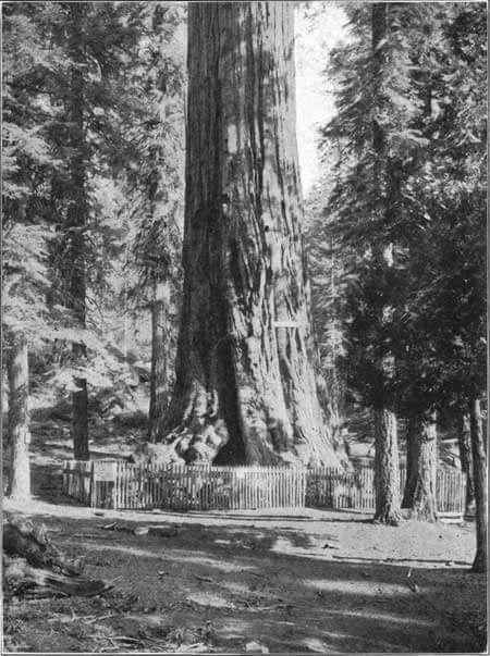
Photograph by Pillsbury Picture Co.
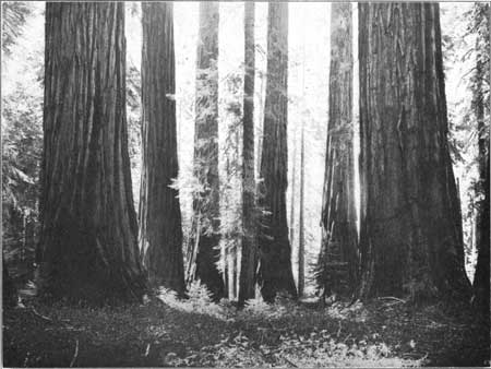
The Mariposa Grove is situated in the southern portion of the Yosemite National Park, 35 miles from Yosemite Valley. There are two other groves of big trees in the Yosemite National Park—the Tuolumne Grove of 20 trees 17 miles northwest of Yosemite Valley and the Merced Grove of 40 trees 9 miles north west of Yosemite Valley.
Huge as the sequoias are, their size is scarcely so wonderful as their age. A tree that has lived 500 years is still in its early youth; one that has rounded out 1,000 summers and winters is only in full maturity; and old age, the three score years and ten of the sequoias, does not come for 17 or 18 centuries. How old the oldest trees may be is not yet certain, but I have counted the rings of 79 that were over 2,000 years of age, of 3 that were over 3,000, and of 1 that was 3,150. In the days of the Trojan War and of the exodus of the Hebrews from Egypt this oldest tree was a sturdy sapling, with stiff, prickly foliage like that of a cedar, but far more compressed.
It was doubtless a graceful, sharply conical tree, 20 or 30 feet high, with dense, horizontal branches, the lower ones of which swept the ground. Like the young trees of to-day, the ancient sequoia and the clump of trees of similar age which grew close to it must have been a charming adornment of the landscape. By the time of Marathon the trees had lost the hard, sharp lines of youth, and were thoroughly mature. The lower branches had disappeared, up to a height of 100 feet or more; the giant trunks were disclosed as bare, reddish columns covered with soft bark 6 inches or a foot in thickness; the upper branches had acquired a slightly drooping aspect; and the spiny foliage, far removed from the ground, had assumed a graceful, rounded appearance. Then for centuries, through the days of Rome, the Dark Ages, and all the period of the growth of European civilization, the ancient giants preserved the same appearance, strong and solid, but with a strangely attractive, approachable quality.
After one has lived for weeks at the foot of such trees, he comes to feel that they are friends in a sense more intimate than is the case with most trees. They seem to have the mellow, kindly quality of old age, and its rich knowledge of the past stored carefully away for any who know how to use it. Often in the search for scientific information in remote parts of the world one comes to some primitive village and inquires whether there are not some old men of long experience who can tell the story of the past. So it is with trees; like old men, they cherish the memory of hundreds of interesting events, and all that is needed is an interpreter.
Photograph by Pillsbury Picture Co.
During the summers of 1911 and 1912 the natural course of the writer’s study of the climate of the past led him to attempt to learn from the big trees at least a part of their story. During the 3,000 or 4,000 years covered by recorded human history, as I have shown in “The Pulse of Asia,” “Palestine and its Transformation,” and various magazine articles, the climate of western and central Asia and of the countries around the Mediterranean Sea appears to have changed. On the whole the climate seems to have grown drier, so that regions which once were fertile have now become desert. Farther north, however, or in regions which are cold and damp because of high altitude, an opposite result has apparently been produced. The relatively dry and warm conditions of the present have changed lands which once were too cold for the practice of agriculture into places where large numbers of people can live in comfort by means of that pursuit. Thus there appears to have been a change in the location of the regions best suited to human occupation. The change has not proceeded regularly, however, but in a pulsatory fashion. It seems to have been interrupted by centuries of exceptional aridity on the one hand and of exceptional moisture on the other. When these pulsations of climate are compared with the course of history a remarkable agreement is noticed. Among a mass of minor details this apparent relationship may be concealed, but the broad movements of races, the rise and fall of civilization, seem to show a degree of agreement with climatic changes so great that it scarcely seems possible to avoid the conclusion that the two are intimately related. Unfavorable conditions of climate, such as a change toward aridity in regions already none too well supplied with water, have apparently led to famines, epidemics, economic distress, the decline of trade, misgovernment, migrations, wars, and stagnation; while favorable changes have fostered exactly opposite conditions.
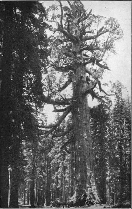
Photograph by Pillsbury Picture Co.
Height, 204 feet; 93 feet in circumference and 29 feet in diameter at base; 64 feet in circumference and 20 feet in diameter at a point 10 feet above the ground.
This theory strikes so profoundly at the roots of all historical interpretation and is of such fundamental importance in its bearing on the future of nations and of the human race as a whole that it demands most careful testing. The first step in carrying on the necessary tests is obviously to determine the exact degree of accuracy of our conclusions as to the dates and nature of climatic changes. Only when that has been done are we prepared to proceed to a fuller investigation of the relation of the changes to historic events.
After some years had been spent in a study of this great problem from various standpoints in Asia, the logical thing seemed to be to take up the same lines of work in some other continent and see how far the two agreed. Fortunately I was invited by Dr. D. T. MacDougal to cooperate with the Department of Botanical Research of the Carnegie Institution of Washington in a study of the climate of the southwestern part of the United States. In general the phenomena of ancient ruins, old strands of inclosed salt lakes, the gravel terraces of rivers, and the distribution and agriculture of the prehistoric population seemed to indicate that the climatic history of America has been the same as that of Asia. The results, however, were unsatisfactory in two respects. In the first place, previous to the time of Columbus we know almost nothing about the dates of events in America, and hence it is impossible to know whether the apparent climatic fluctuations of America agree in time with those of Asia. In the second place, a theory is a dangerous thing. Strive as he will, the author is apt to be partial to it and to interpret all that he sees in such a way as to fit his preconceived ideas. During my work in Arizona, New Mexico, and old Mexico I knew that when its results were announced critics would say, “That is all very interesting, but not convincing. You went out West expecting to find evidences of pulsatory changes of climate during historic times, and, of course, you found them. We will wait a while before we believe you.”

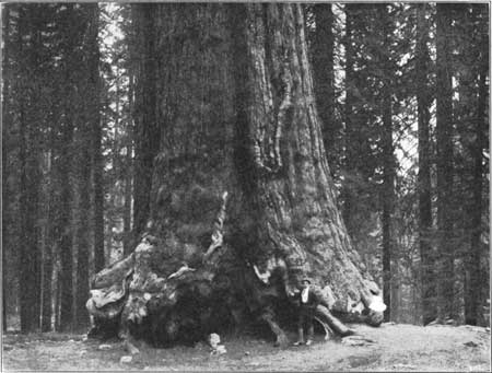
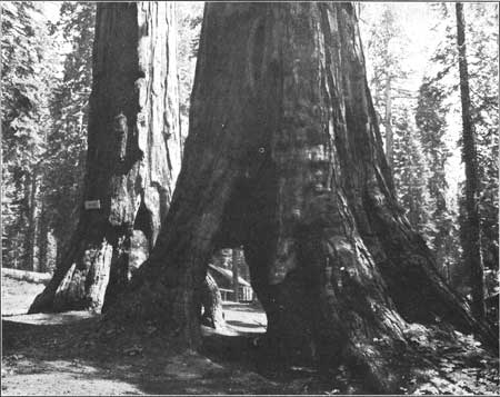
Photograph by Pillsbury Picture Co.
Height, 227 feet; diameter, 26 feet through the opening; 10 feet above the ground the diameter is 19 feet and the circumference is 60 feet. The road was cut through this tree in 1880.
Manifestly it was necessary to devise some new line of research which should not only furnish dates, but should prove positively the existence or nonexistence of changes of climate, and should do it in such a way that the investigator’s private opinions, his personal equation, so to speak, should not be able to affect his results. The necessary method was most opportunely suggested by an article published in the Monthly Weather Review in 1909 by Prof. A. E. Douglass, of the University of Arizona. In regions having a strongly marked difference between summer and winter it is well known that trees habitually lay on a ring of wood each year. The wood that grows in the earlier part of the season is formed rapidly and is soft in texture, while that which grows later is formed slowly and is correspondingly hard. Hence each annual ring consists of a layer of soft, pulpy wood surrounded by a thinner layer of harder wood which is generally of a darker color. Except under rare conditions only one ring is formed each year, and where there are two rings by reason of a double period of growth, due to a drought in May or June followed by wet weather, it is usually easy to detect the fact. In the drier parts of the temperate zone, especially in regions like Arizona and California, by far the most important factor in determining the amount of growth is the rainfall. Prof. Douglass measured some 20 trees averaging about 300 years old. He found that their rate of growth during the period since records of rainfall have been kept varies in harmony with the amount of precipitation. Other investigators have since done similar work elsewhere, and it is now established that in regions with cold winters and dry summers the thickness of the annual layers of growth gives an approximate measure of the amount of rain and snow.
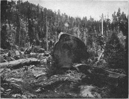
Obviously the best trees upon which to test the theory of climatic changes are the big trees of California. They grow at an altitude of 6,000 or 7,000 feet on the western slope of the Sierra Nevadas. Abundant snow falls in winter and there is a fair amount of rain up to about the 1st of June, but the rest of the warm season until the end of September is dry. Hence the conditions are highly favorable to the formation of distinct, easily-measured rings. The size of the trees makes the rings fairly thick, and hence easy to see. The only difficulty is that the number of trees which have been cut is small. The region where they grow is relatively inaccessible, the huge trunks are very difficult to handle, and the wood is so soft that its uses are limited to a few purposes for which great durability is required. Hence several years may pass without the cutting of more than a few scattering trees. The resistance of the wood to decay is so extraordinary, however, that stumps 30 years old are almost as fresh as when cut, and their rings can easily be counted. As climatic records they are as useful as trees that were cut the present year, if only one can ascertain the date when they were felled.
Photograph by Pillsbury Picture Co.
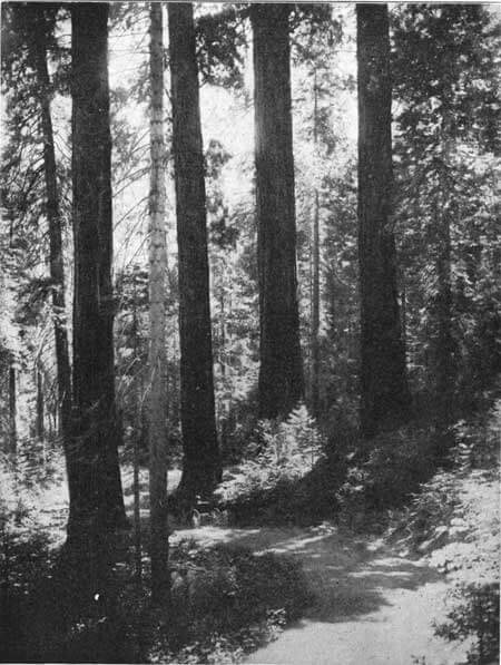
Toward the end of May, 1911, I left the train at Sanger, near Fresno, in the great inner valley of California, and with two assistants drove up into the mountains through the General Grant National Park to a tract belonging to the Hume-Bennett Lumber Co. There we camped for two weeks, and then went to a similar region, some 60 miles farther south on the Tulare River, east of Portersville. Few parts of the world are more delightful than the Sierras in the early summer. In the course of our work we often tramped through valleys filled with the straight, graceful cones of young sequoias overtopped by the great columns of their sires. Little brooks or rushing streams full of waterfalls flowed in every depression, and a drink could be had whenever one wished. On the sides of the valleys, where the soil is thin and dry, no young sequoias could be seen, although there were frequent old ones, a fact which suggests that conditions are now drier than in the past. Other trees, less exacting in their demands for water, abound in both their young and old stages, and one climbs upward through an array of feathery pines, broad-leaved cedars with red bark, and gentle firs so slender that they seem like veritable needles when compared with the stout sequoias.
Photograph by Pillsbury Picture Co.
We tramped each day to our chosen stumps, sometimes following old chutes made by the lumbermen to guide the logs down to the valleys, and sometimes struggling through the bushes, or wandering among uncut portions of the primeval forests. Often there was frost on the ground during the first week or two, and the last rains of the spring made the ground oozy, while the flat tops of the stumps smoked in the summer sun as soon as the clouds disappeared. Our method of work was simple. As soon as we reached a place where sequoias had been cut, we began prospecting for large stumps. The method of cutting the trees facilitated our work by furnishing a smooth sawed surface. Before the lumbermen attack one of the giants they build a platform about it 6 feet or more above the ground and high enough to be clear of the flaring base of the trunk. On this two men stand and chop out huge chips, sometimes a foot and a half long. As the cutting proceeds a great notch is formed, flat on the bottom and high enough so that the men actually stand within it. In this way they chop 10 feet more or less into the tree, until they approach the center. Then they take a band saw 15 or 20 feet long and go around to the other side. For the next few days they pull the great saw back and forth, soaking it liberally in grease to make it slip easily, and driving wedges in behind it in order to prevent the weight of the tree from resting on the saw. Finally, when the tree is almost cut through, more wedging is done, and the helpless trunk topples over with a thud and a stupendous cracking of branches that can be heard a mile. The sawn surface exposes the rings of growth so that all one has to do is to measure them, provided the cutting has taken place recently. In the case of older stumps we sometimes were obliged to scrape the surface to get rid of the pitchy sap which had accumulated on it. In other cases, especially where the stumps had been burned, we had to chisel grooves or take a whisk-broom and sweep off an accumulation of needles and dirt.

When all was ready, two of us lay down on our stomachs on the top of the stump, or it might be on two stumps standing close together, while the third sought the shade, or the sun, or a shelter from the rain, as the weather might dictate. The two who were on the stump were equipped with penknife, ruler, and hand lens. The ruler was placed on the fiat surface of the stump with its zero at the edge of the outer ring. Then we counted off the rings in groups of 10, read the ruler and called off the number to the one who sat under shelter with notebook and pencil. Had the lumbermen seen us we should have appeared like crazy creatures as we lay by the hour in the sun and rain calling out “forty-two,” and being answered by the recorder, “forty-two”: “sixty-four,” “sixty-four”: “seventy-eight,” “seventy-eight,” and so on, interminably. It was not inspiring work merely to measure, and it was distinctly uncomfortable to lie on one’s stomach for hours after a hearty meal. Often it was hard to see the rings without a lens, and in some cases even the lens scarcely showed them all, for the smallest were only two-hundredths of an inch thick, very different from some of the big ones, half an inch thick. Nevertheless, the work was decidedly interesting. If we were busy on different radii of the same tree there was always a rivalry as to who would finish first but undue haste was tempered by the danger that the results of our two measurements might not agree. The chief interest therefore lay in seeing how nearly the same number of rings would be counted on different radii. If we were at work on different trees the rivalry was as to whose tree would turn out oldest; for, like the rest of mankind, we had a feeling of personal merit if the thing with which we by pure chance were concerned happened to turn out better than that of our neighbor.
One of our chief difficulties lay in the fact that in bad seasons one side of a tree often fails to lay on any wood, especially in cases where a clump of trees grow together in the sequoias’ usual habit, and the inner portions do not have a fair chance. Often we found a difference of 20 or 30 years in radii at right angles to one another; and in one extreme case, one side of a tree 3,000 years old was 500 years older than the other, according to our count. All these things necessitated constant care in order that our results might be correct. Another trial lay in the fact that in spite of the extraordinary durability of the wood, a certain number of decayed places are found, especially at the centers of the older trees, exactly the places which one most desires to see preserved. Even these decayed places, however, added their own small quota of interest. Looking down into the damp, decayed holes, we frequently saw the heads of greenish frogs, which slowly retreated if we became inquisitive and poked them. At other times, in drier places, lizards of a smooth, unpleasant complexion of brownish gray wriggled hastily into cavities in the rotten wood. Once I pulled off a large decayed slab from the side of a stump, and started back in surprise when two creatures with yellowish-brown bodies and black wings flew out. I was about to look for a bird’s nest when one of my companions called out ” Bats.”
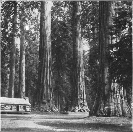
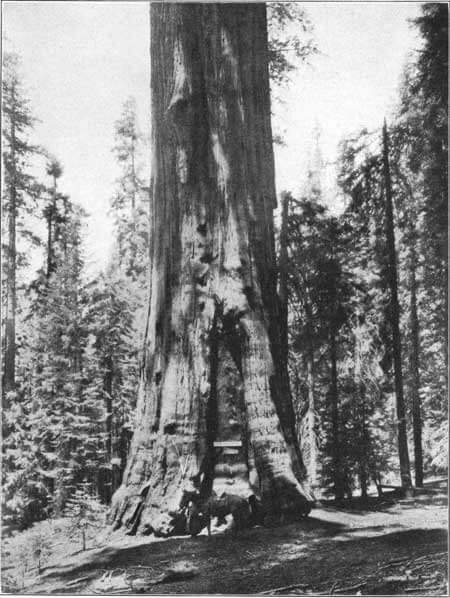
(Editor note: This is located in Grant Grove in Kings Canyon National Park)
Height, 264 feet; diameter, 35 feet. The General Grant Grove, in the park of the same name, has an area of 235 acres and contains 190 trees exceeding 10 feet in diameter.
The frogs, lizards, and bats did not trouble us, and, fortunately, we were free from mosquitoes. There was one creature, however, which sometimes seriously interfered with our work. As we lay on our stomachs, our left fists resting on the black surface of a stump to prop our unshaven chins, and our right hands rapidly touching ring after ring with a penknife as we counted our decades—as we lay thus, with eyes closely focused at a distance of about 8 inches, frightful forms came rushing into the field of vision. They were black and horny, with powerful nippers on their heads, and with white hairs on their abdomens, giving them a moldy look. They seemed nearly as large as mice, and their speed of movement was positively alarming. With open nippers they rushed at our rulers and knives and tried them to see if they were edible. Sometimes they even nippd our hands, and more than once one of us uttered a sharp exclamation and jumped so as to throw knife and ruler to the winds and cause the waste of 10 or 15 minutes in finding the place again. When we brushed the creatures away and looked at them from the normal distance they proved to be nothing but large black ants, about half an inch long. More pertinacious insects I never saw. Again and again I brushed an ant away to a distance of 6 or 8 feet, and watched that same ant turn the moment it alighted and rush back to the attack, and it did this not once but five or six times.
During the 12 weeks that we were in the mountains in the two seasons of 1911 and 1912 we succeeded in measuring over 450 trees, 79 of which were 2,000 or more years of age. The others were of various ages down to 250 years, for we measured a considerable number of relatively young trees for purposes of comparison. The process of constructing the climatic curve from the data thus obtained is less simple than might at first appear. The obvious method is to ascertain the average growth of all the trees for each decade, from the earliest, times to the present, and then to draw a curve showing how the rate has varied. The high places on such a curve will indicate times of comparative moisture, while the low places will indicate aridity. This method is too simple, however, for it takes no account of the fact that all trees grow faster in youth than in old age. Each species has its own characteristic curve of growth, as it is called. For example, during the first 10 years of its life the average Sequoia washingtoniana grows about an inch in radius, that is, it reaches a diameter of 2 inches; at the age of 200 years the average tree adds about nine-tenths of an inch to its radius each decade; at the age of 500 years about six-tenths of an inch; and at the age of 1,700 only three-tenths. These figures have nothing to do with the rainfall, but indicate how fast the tree might be expected to grow if they were subject at all times to the average climatic conditions, without any variations from year to year.
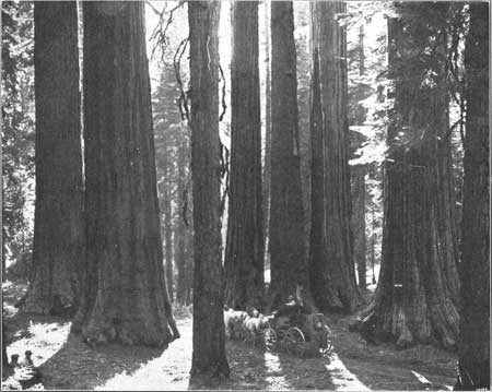
The Giant Forest has an area of 3,200 acres and contains 500,000 trees, of which 5,000 exceed 10 feet in diameter. There are 11 other groves in the Sequoia National Park ranging from 10 to 2,000 acres in area and containing from 6 to 3,000 trees exceeding 10 feet in diameter.
Evidently, if we desire to institute a fair comparison between the growth of a tree 200 years old and of one 1,700 years old, we must either multiply or divide by 3. By applying such corrections to each measurement among the 105,000 which made up the work of our two summers, we are able to eliminate the effect of differences in the ages of the trees. The process is purely mathematical and depends in no respect upon the individual ideas of the computer. In addition to the correction for age, there is another, which I have called the correction for longevity. What sort of tree is likely to have a long life? Is it a vigorous, well-grown tree, the kind that one would pick out as especially flourishing in its youth? Not at all. The tree which is likely to live to a ripe old age of two or three thousand years grows slowly in its early days. Its actual rate of growth may be only half or two-thirds as great as that of the trees which attain an age of 500 or 1,000 years. Hence, in order to institute a fair comparison between the rate of growth in the days of Darius and now it is necessary to make still further corrections. This process, like the other, is purely mathematical. The only difficulty is that in order to secure high accuracy a large number of trees of all ages is necessary. It is easy to obtain plenty of young trees under 2,000 years of age, but older ones are so scarce that we have not obtained enough to render the corrections fully exact. Hence in the earlier parts of the curve, the details are less exact than could be desired, and the fluctuations are relatively too great, since they are not smoothed out by the use of a large number of trees. In the portion of the curve since about 100 B. C., however, the fluctuations for minor periods and also for centuries show no appreciable errors except such as are due to special accidents. Nevertheless there is some doubt as to whether the curve as a whole in its descent from early times down to the present should slope more or less than is here shown.
The accompanying diagram sums up the results of our work on the big trees as compared with the results of work of an entirely different kind upon the climatic fluctuations of Asia. Horizontal distance indicates time; the diagram begins at the left-hand end with 1300 B. C.. and ends on the right with 1900 A. D. Vertical distance indicates a greater or less amount of rainfall or more or less favorable conditions of plant growth. The solid line is the curve of the sequoias. During the periods where it is high, abundant moisture stimulated rapid growth; where it is low, periods of aridity lasting often for centuries checked the growth of the trees. The other curve, the dotted line, is reproduced unchanged from the author’s volume on “Palestine and its Transformation.” It represents the state of our knowledge of the changes of climate of western and central Asia at the time when that volume was written in 1910. The evidence upon which it is based is of very diverse types, and varies greatly in accuracy and abundance at different periods. For example, the low portion of the curve about 1200 B. C. is based on records of ancient famines, and upon the fact that at that time great movements of desert peoples took place in such a way as to suggest that the deserts had become much less habitable than formerly. A few hundred years later the curve is high, because at this time not only did great prosperity prevail in regions which are now poverty stricken for lack of rainfall, but the kings of Assyria and the other countries lying near the Arabian Desert appear to have been able to take their armies in comparative comfort across regions where small caravans can not now pass, and which even the hardy Arab raiders avoid. At a later time, 300 A. D., the curve drops low, because at this period a great number of towns were abandoned in central Asia and in all the drier parts of the Continent; trade routes which had formerly been much frequented were absolutely given up in favor of those where water and forage were more easily obtained; and in countries like Syria stagnation seems to have prevailed, as is indicated by the scarcity of building operations during these years. The curve dips low at this point simply because evidences of aridity began to be conspicuous; but probably it dips too low, for there is as yet no means of obtaining exact data. In the seventh century A. D. evidence of the same kind as in the third causes the curve to drop still lower, but here we have additional proof of aridity in the form of traditions of prolonged famines in Arabia. Moreover, at about this same time the waters of the Caspian Sea and of other lakes without outlets were not replenished by rain, and hence fell to a level so low that buildings were built upon what is now the bottom of the lake. Then, at a later date, about 1000 A. D., the ruins in the desert were partially reoccupied, the old trade routes began to revive, the lakes rose higher than their present level, and prosperity was the rule in many regions which had formerly suffered from aridity. These bits of evidence, gathered here and there, have enabled the curves to be drawn, but accuracy is as yet out of the question. At most the curves are a mere approximation, showing some of the main climatic pulsations, but likely to be greatly modified as further investigation is made. On the whole there are indications that further knowledge of the Asiatic curve will prove that it is much more like the California curve than now appears. Yet in the main the two curves even now show a considerable degree of agreement, and in that agreement lies the strongest evidence that both are correct in principle, although they may be wrong in detail.

Let us begin at the left-hand end far back at the time of the Trojan War. There, about 1200 B. C., both curves drop very low, indicating an epoch of sudden and severe desiccation. That particular period, historians tell us, was one of the most chaotic in all history. The warlike progenitors of the Greeks swarmed into the country where they were later to grow great, the Mittani or Hittites came down out of the mountains into northern Mesopotamia, tribes from Arabia and the Libyan Desert swarmed into Egypt and brought civilization down to the lowest possible ebb, famines such as that in the days of Joseph appear in the Egyptian chronicles, the lands surrounding Arabia on the north and northwest were swamped by the great Aramean invasion, and, in general, war, migrations, and disaster prevailed. If America was then inhabited we can scarcely doubt that similar disasters took place there; for, if the trees are to be trusted, vast areas in dry regions such as Mexico and the southwestern part of the United States, the only places where dense agricultural populations could have dwelt, must have fallen off tremendously in productivity.
Some fluctuations of the California curve, such as the upward bend between 1000 and 1100 B. C., are missing in that for Asia not necessarily because they did not exist, but more probably because no facts yet happen to have been lighted upon which furnish evidence of them. The famine in the days of Elijah appears in both curves. Apparently at that time the climate did not become extremely dry, nothing like so bad as it had been a few hundred years earlier during the twelfth century, but there was a rather distinct falling off in the amount of rainfall as compared with the uncommonly good conditions of the preceding century. About seven hundred years before Christ both curves stand high in the day when the Greeks were laying the foundations of their future greatness and the empires of Mesopotamia were at their height. Then comes a pronounced falling off, with a recovery three or four hundred years before Christ, another decline culminating about 200 B. C., and a recovery reaching a high point about 50 B. C. The time of Christ, the great era of universal peace under the sway of Rome, was apparently an epoch of favorable climate, a time of abundant rain and consequent good crops in all the countries around the Mediterranean Sea and eastward in Asia, as well as in California. Next comes a long period of decline culminating six or seven centuries after the time of Christ. The sudden drop of the Asiatic curve about 300 A. D. is probably exaggerated, as are those from 550 to 650 A. D. and in 1200. Nevertheless, there can be little question as to the general agreement of the two curves in showing that an epoch of extraordinary aridity reached its climax in the seventh or eighth century of our era, and that another period of aridity occurred in the thirteenth century. Previous to the seventh century the Roman world had been in the direst straits because of the invasions of barbarians, driven from their homes, it would seem, by increasing aridity and the consequent difficulty of obtaining a living. Then, toward the end of the long period of drought, there occurred the tremendous outpouring of the Arabs, unified by Mohammedanism, as us universally agreed, and also spurred by hunger, as we infer from a study of climate. Thus the Dark Ages reached their climax. No period in all history, save that which centers 1200 B. C., was more chaotic; and that early period also appears to have been a time of greatly diminished rainfall.
Height, 286 feet; diameter. 36 feet.
It is impossible here to trace further the correspondence of the two curves and their relation to history. The essential point is this: By means of a rigid mathematical test we have worked out the climatic changes of California. From ruins, lacustrine strands, traditions, famines, and many other lines of evidence we have worked out the changes in Asia. Thus by methods absolutely dissimilar we have constructed curves showing climatic fluctuations in parts of the world 10,000 miles apart. In essentials the two agree in spite of differences in detail. It therefore seems probable not only that climatic pulsations have taken place on a large scale during historic times, but that on the whole the more important changes have occurred at the same time all around the world, at least in the portion of the north temperate zone lying from 30° to 40° north of the Equator. This, in itself, does not prove that great historic changes have occurred in response to climatic pulsations, but it goes far in that direction. It introduces a new factor into that most profound and far-reaching of the problems of history—the cause of the rise and fall of nations.

